Tomorrow will be sunny with a High of about 45-47, morning Low down about 24-25.
Tuesday looks mostly sunny during the day, clouds increasing in the evening. High in the lower 50's and the morning Low in the 25-28 range.
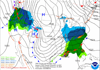
We'll have to watch Tuesday night into Wednesday for a wintry mix. We'll at least have a cold rain, but it remains to be seen if any snowflakes or even ice pellets mix with it. Best chance of snow is up in Tennessee and far Northwest Alabama, the way things are looking now.
There is a Winter Storm Watch in effect for much of Central Tennessee. At this point, no such watches, warnings, or advisories have been required for Southern Tennessee bordering Alabama, much less for North Alabama. Everybody really needs to chew on tomorrow's data before making a really detailed forecast of what places are likely to see what type of wintry mix and how much accumulation is likely, if any.
For now will forecast showers likely on Wednesday with a High of 40 or so, Low of 30 or so, and some of those could be snow showers, although it's more likely around Cullman that we'll just see a cold rain. But let's keep that chance of snow in mind, even though it rarely happens around here, just in case.
Thursday will be mostly sunny and bitterly cold compared to what we've gotten used to lately, back to January style - High in the lower 30's and Low in the upper 10's.
The latest guidance doesn't make the snow potential look what I'd call particularly worrisome or even consistent. Most of us in North Alabama will probably just get a cold rain with maybe some flurries or pellets in the mix at times. Tennessee needs to watch this a little closer, especially in and near the Winter Storm Watch area. But even there, this is not a slam-dunk guarantee of major snow accumulations. It's just letting people know there's a pretty decent potential in those areas.
Here are the latest flood advisories.
Of course the main story last night was the damaging wind and tornadoes - compiled some storm surveys here. Looks like the only injuries in our region were a couple people hurt in a mobile home who were not able to get out in time. I was glad to see a couple other stories of people who did get the warnings and were able to get to safety before it hit. I believe one of those stories also involved people in a trailer who were able to leave and get into a shelter.


No comments:
Post a Comment