Playing catch up with this one as my weather radio did not go off for it. Think the device must be just about done for. Anyway the timing of seeing it is pretty good since the storms are getting ready to cross the MS/AL state line into Northwest Alabama.
7:10 PM - Folks in Lauderdale, Colbert, Franklin, Marion, Lamar Counties, be getting ready to take cover from storms with potential for damaging winds and large hail.
7:12 - And now we have a Severe Thunderstorm Warning for Lamar County. Also includes Northern Pickens County in West Central Alabama, down to Reform, clips the Northern part of that town.
7:18 - This is actually round two of this system. I can see that earlier some severe thunderstorms moved through and even prompted a Tornado Warning for Jackson and Dekalb County. My weather radio alerts for Cullman, Walker, and Winston Counties and never went off for this Watch. The reception is excellent if I push the button to listen to the weather, and it is on alert. But the light is not even on. So I didn't doze through the watch alert tone (which is hard to do anyway but has happened a few times over the years). This device did not tone for it this time. The problem could be on my end, or there could be a problem with the communications at the moment, a technical glitch. I sort of hope it is not the latter since we have an organized bunch of severe thunderstorms coming into the area as we get into the evening hours here.
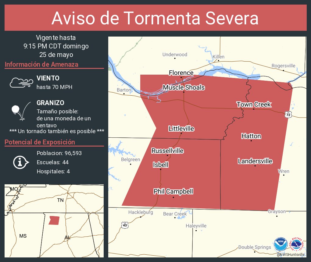
7:22 - Interesting situation for Lauderdale, Colbert, and Franklin Counties. This new warning does include Muscle Shoals. But the wind is actually estimated below severe limits, 50 mph gusts. The hail is what makes this storm severe, estimated at one inch in diameter, quarter size.
7:36 - There is plenty of lead time as these storms move out of North/Central Mississippi over into West/Northwest Alabama.
Ideally you want to be in a small interior room (or hallway) on the lowest floor of a sturdy house (much better than a mobile home, especially if there are trees around, less vulnerable to winds) while these storms pass.
If the best you can do is get away from windows, I'd at least do that. And other things that make good sense, like not using electrical stuff while these storms are coming through with a good bit of cloud-to-ground lightning.
But the wind gusts and hail are what make them severe.
7:41 - Some of the hail/wind impacts from these storms could be fairly significant, new note from NWS Huntsville.
7:53 - Just got the new outlook from SPC in Norman, Oklahoma, only going to post the local version of it here since we've got local issues already.
They've got a 30% chance of damaging winds along and West of I-65, a more basic 15% risk for Eastern Counties.
For severe hail, the basic 15% risk is generally along and West of the Interstate, and then East of there, the threat of severe hail drops to about 5%.
And there is actually a chance of an isolated tornado outlooked with this, it's just very low, about 2%.
People in mobile homes might consider going to visit a friend or relative with a sturdier house ahead of these storms just in case something really fires up. That's a close judgement call with this system tonight.
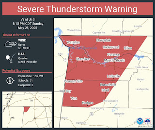
We just got a Severe Thunderstorm Warning for the Shoals warning of golfball-or-larger hail. Going to post that warning separately and sort of ride with things from there as it moves across the state.
Well actually no, it is not a new warning, just a statement on the existing warning.
And the new warning for Marion County only warns of quarter-sized hail. This includes the city of Hamilton. So I guess I'll hold it here in this post for a while.
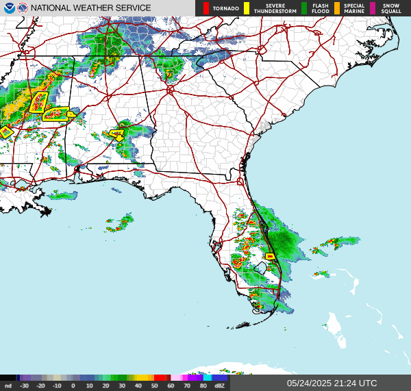
8:01 PM - But here's a look at the radar with these storms. There is obviously a threat for severe hail here along with the damaging wind gusts.
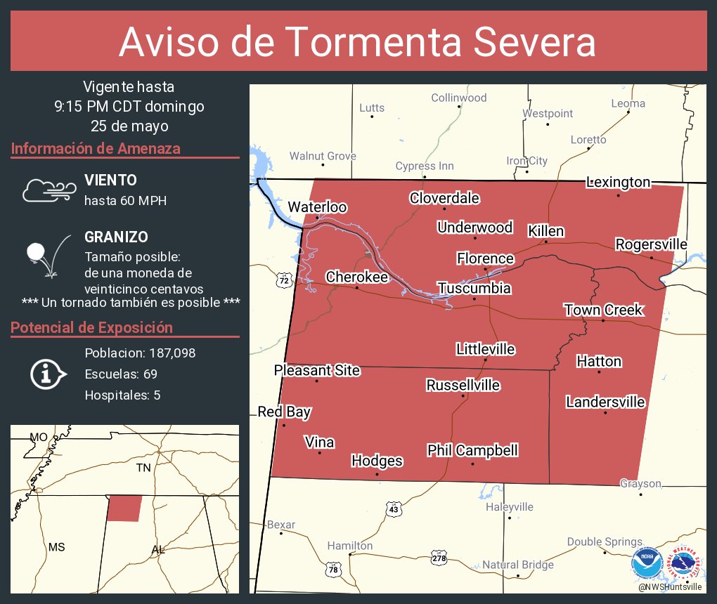
Newest warning stretches all the way down to Guin and Winfield, also Detroit and Sulligent back in Lamar County.
WVTA from Mississippi has been covering this activity, even though tonight is more of a hail/damaging thunderstorm wind than a tornado threat.
8:05 - Looks like Ryan Hall is on it too.
And so is Max Velocity. Only discovered him recently.
But he's focused back on Texas where the weather is worse this evening.
And Brad Travis has a live stream going out of Huntsville.
So does Jeff Castle.
These guys are working for the weekend this time. Props to them for working a holiday weekend for a lower-end threat like this.
And actually WHNT-19 has gone live for this one as well. I don't recognize the meteorologist yet, but she seems to be doing a good job. Things have changed over the years. When Dan Satterfield was in charge at that station, they were my first choice for live coverage. Now they're my third in Huntsville. And that's mainly because their online stream is not always available when I see the other two stations doing a stream. And their newscasts run on a delay for computer users, which is the only way I can watch them, online. I can't pick up local TV channels where I live. I've tried three different antennas over the past few years. Anyway I'm not familiar with this young lady's work yet, but I know Ben Smith and Danielle Dozier do good work on this station these days. Ben Smith has been around forever.
Going to start a new post for the new warning that includes Moulton. It is even showing a little rotation, concerning.
URGENT - IMMEDIATE BROADCAST REQUESTED
Severe Thunderstorm Watch Number 324
NWS Storm Prediction Center Norman OK
325 PM CDT Sun May 25 2025
The NWS Storm Prediction Center has issued a
* Severe Thunderstorm Watch for portions of
Northern Alabama
Northwest Georgia
Southern Middle Tennessee
* Effective this Sunday afternoon and evening from 325 PM until
1100 PM CDT.
* Primary threats include...
Scattered damaging wind gusts to 70 mph possible
Isolated large hail events to 1 inch in diameter possible
A tornado or two possible
SUMMARY...A line of storms will move southeastward this afternoon
and pose mainly a damaging wind risk. Additional storms, perhaps as
a well-organized line, are expected to move into the region,
particularly northern Alabama, by evening, posing an additional
round of severe storms.
The severe thunderstorm watch area is approximately along and 45
statute miles north and south of a line from 25 miles west southwest
of Muscle Shoals AL to 20 miles south southeast of Chattanooga TN.
For a complete depiction of the watch see the associated watch
outline update (WOUS64 KWNS WOU4).
PRECAUTIONARY/PREPAREDNESS ACTIONS...
REMEMBER...A Severe Thunderstorm Watch means conditions are
favorable for severe thunderstorms in and close to the watch area.
Persons in these areas should be on the lookout for threatening
weather conditions and listen for later statements and possible
warnings. Severe thunderstorms can and occasionally do produce
tornadoes.
&&
OTHER WATCH INFORMATION...CONTINUE...WW 322...WW 323...
AVIATION...A few severe thunderstorms with hail surface and aloft to
1 inch. Extreme turbulence and surface wind gusts to 60 knots. A few
cumulonimbi with maximum tops to 550. Mean storm motion vector
29045.
...Guyer
WOUS64 KWNS 252022
WOU4
BULLETIN - IMMEDIATE BROADCAST REQUESTED
SEVERE THUNDERSTORM WATCH OUTLINE UPDATE FOR WS 324
NWS STORM PREDICTION CENTER NORMAN OK
325 PM CDT SUN MAY 25 2025
SEVERE THUNDERSTORM WATCH 324 IS IN EFFECT UNTIL 1100 PM CDT
FOR THE FOLLOWING LOCATIONS
ALC009-019-033-043-049-055-059-071-077-079-083-089-095-103-
260400-
/O.NEW.KWNS.SV.A.0324.250525T2025Z-250526T0400Z/
AL
. ALABAMA COUNTIES INCLUDED ARE
BLOUNT CHEROKEE COLBERT
CULLMAN DEKALB ETOWAH
FRANKLIN JACKSON LAUDERDALE
LAWRENCE LIMESTONE MADISON
MARSHALL MORGAN
GAC047-055-083-115-295-313-260400-
/O.NEW.KWNS.SV.A.0324.250525T2025Z-250526T0400Z/
GA
. GEORGIA COUNTIES INCLUDED ARE
CATOOSA CHATTOOGA DADE
FLOYD WALKER WHITFIELD
TNC031-051-061-065-103-115-127-153-260400-
/O.NEW.KWNS.SV.A.0324.250525T2025Z-250526T0400Z/
TN
. TENNESSEE COUNTIES INCLUDED ARE
COFFEE FRANKLIN GRUNDY
HAMILTON LINCOLN MARION
MOORE SEQUATCHIE
ATTN...WFO...BMX...MRX...HUN...OHX...FFC...