

FORECAST:
Friday (High 75, Low 56): Mostly sunny. Mild.
Saturday (High 74, Low 58): Partly to mostly cloudy. Scattered showers and thunderstorms are possible - some storms could be strong, producing strong wind gusts and hail.
Sunday (High 81, Low 62): Mostly cloudy. Numerous rounds of showers and thunderstorms are possible, and a few storms could produce strong wind gusts and hail.
EXTENDED OUTLOOK:
Memorial Day (High 79, Low 65): Rain and thunderstorms likely.
Tuesday (High 78, Low 66): Mostly cloudy with a 50% chance of showers/thunderstorms.
Wednesday (High 78, Low 63): Partly cloudy with a 30% chance of showers/thunderstorms.
Thursday (High 77, Low 61): Partly to mostly sunny with a 20% chance of showers/thunderstorms.
READING TEA LEAVES:
Friday May 30 (High 79, Low 62): Partly to mostly sunny with a 20% chance of showers/thunderstorms.
Saturday May 31 (High 80, Low 61): Partly to mostly sunny with a 20% chance of showers/thunderstorms.
Sunday June 1 (High 82, Low 60): Mostly sunny with a 20% chance of showers/thunderstorms.
PRONÓSTICO:
Viernes (Máxima: 75, Mínima: 56): Mayormente soleado. Templado.
Sábado (Máxima: 74, Mínima: 58): Parcialmente a mayormente nublado. Posibles chubascos y tormentas dispersas; algunas tormentas podrían ser fuertes, con fuertes ráfagas de viento y granizo.
Domingo (Máxima: 81, Mínima: 62): Mayormente nublado. Posibles numerosas rondas de chubascos y tormentas, y algunas tormentas podrían producir fuertes ráfagas de viento y granizo.
PERSPECTIVA EXTENDIDA:
Día de los Caídos (Máxima: 79, Mínima: 65): Probabilidad de lluvia y tormentas.
Martes (Máxima: 78, Mínima: 66): Mayormente nublado con un 50 % de probabilidad de chubascos/tormentas.
Miércoles (Máxima: 78, Mínima: 63): Parcialmente nublado con un 30 % de probabilidad de chubascos/tormentas.
Jueves (Máxima: 77, Mínima: 61): Parcialmente soleado con un 20 % de probabilidad de lluvias o tormentas.
LEYENDO LAS HOJAS DE TÉ:
Viernes 30 de Mayo (Máxima: 79, Mínima: 62): Parcialmente soleado con un 20 % de probabilidad de lluvias o tormentas.
Sábado 31 de Mayo (Máxima: 80, Mínima: 61): Parcialmente soleado con un 20 % de probabilidad de lluvias o tormentas.
Domingo 1 de Junio (Máxima: 82, Mínima: 60): Mayormente soleado con un 20 % de probabilidad de lluvias o tormentas.
When it comes to Spanish translations of forecasts, I don't know if it's accurate to use the word "chubasco" and also mention "tormentas". I think "lluvia" means a rain shower, but "chubasco" means more the types of popcorn showers/thunderstorms we get mainly in summer around here. And then "tormenta" is more for a straight thunderstorm with a good bit of lightning in it. But maybe a "chubasco" covers rain and thunder in one words. I'm not sure on this. And I doubt I'll get any feedback. But just throwing it out there in case anybody cares. Which frankly is the spirit of this whole blog anymore.
DISCUSSION:
It was a mostly sunny day in Cullman with a High of 79 and Low of 57. Winds have been variable, but it's still been pretty breezy, with gusts up to about 15 mph during much of the day. Insofar as a wind direction has been established now, it's usually from the Northwest.

We've got some light showers moving through Southern Tennessee here at 8:40 PM CDT.


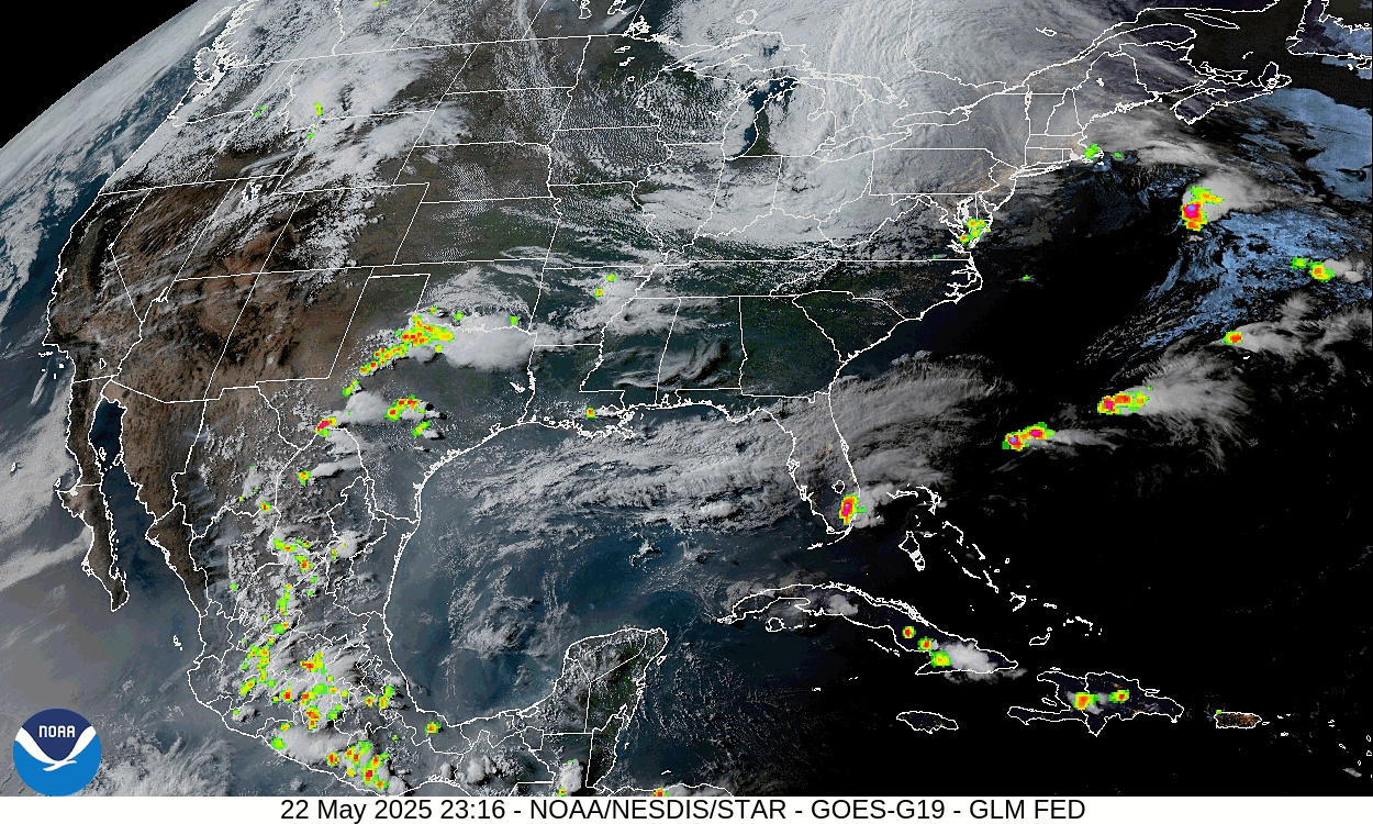

Also got some rain around Memphis into Northern Mississippi. Some thunderstorms in North Carolina and the Florida Peninsula. And actually a few thunderstorms reaching severe limits out there in Texas.
Here back at the ranch, our reinforcing cold front is down to about Montgomery.


The only real severe weather in the country right now is out in Texas, mainly the Central part of the state, a cluster of storms producing large hail and damaging wind gusts.

This evening's radiosonde sounding from Birmingham shows marginally unstable air, which is typical as we get toward summer, to have decent instability. Wind shear is fairly stout as far as speed but not with direction.

Then at Nashville, the wind shear is a bit stronger, but the air is definitely stable. They were at 74 degrees with a dewpoint of 45 at 7 PM CDT/00Z. So that's really good and stable air. That will be filtering down farther South behind this front.


Now as much as I'd like to say we've got a totally clear forecast ahead, this weekend looks more unsettled, long holiday weekend. This front is going to lift back northward as a warm front. And that will present some nice little forecast challenges. So let's dig into those.


Then on Saturday as the warm front lifts back northward, we'll be dealing with a shortwave trough out of MS that will bring some rain/thunderstorm chances.


In fact, the Storm Prediction Center has outlooked most of North/Central Alabama for a marginal 5% threat of severe thunderstorms on Saturday because of some concern that this looks like a MCS (mesoscale convective system, basically a cluster of thunderstorms that can get on the strong side and is common in the summertime, or now as we're transitioning to summer) setup along that shortwave from Mississippi. So we could see a cluster or two of storms capable of damaging wind gusts, maybe some hail.
Overall Saturday looks like a partly to mostly cloudy day with scattered showers and thunderstorms possible - a few could get strong, the High temperature about 74-76 range, the Low about 56-58 range.


Will bump rain chance up to 50/50 for Sunday with a High near 80 or so, Low of 60 or so.


And the weather looks pretty similar for Tuesday although the High might be more in the upper 70's. The front does finally start to get moving to the Southeast again.


Then on Wednesday I think we do get a frontal passage but with some rain left over behind it.
At the moment, thinking of bringing rain chance down to 50% for Tuesday, then 30% for Wednesday.
Also going to throw in a mention of possibility of strong storms for Sunday and Monday, even though the risk of any reaching severe limits (by wind gusts or hail) is marginal. Have to look at the overall pattern and call it straight down the middle.
Looks like a High in the upper 70's, Low in lower 60's for Wednesday.


And I think the GFS is overdoing the moisture for next Thursday but will keep a 20% chance of rain in there, High in upper 70's again, Low near 60.


Then peeking into the land of reading tea leaves, next weekend as we get into the month of June looks pretty good for easing into summer, Highs near 80, Lows near 60 with only a 20% chance of rain each day. And for this setup, I think it's reasonable to include that up in an official forecast. We can have some stronger storms that pulse up and briefly become severe in summer, but generally speaking, our severe weather season is over until about November. Hurricane season is about to start, and a lot of people think it'll be more active than normal, as last year's was, so if anybody thinks the weather is about to get too boring . . . I doubt it. Just depends on where you watch. Lord knows we can be a lot hotter than this in late May/early June. Things are looking pretty good around here aside from a wet holiday weekend with a few storms in the mix.


We could easily see up to 3 inches of rainfall totals over much of the area over the next week. But the risk for flooding looks to stay on the low end.


No comments:
Post a Comment