Thursday (High 57, Low 51): Rainy and breezy. Rain may be heavy at times, and an isolated storm or two is possible.
Friday (High 62, Low 52): Rain coming to an end by late morning. Becoming mostly sunny and staying a little breezy.
Saturday (High 61, Low 35): Sunny. Cool.
Sunday (High 69, Low 48): Rain likely - storms possible.
Monday (High 55, Low 43): Partly to mostly sunny.
Tuesday (High 52, Low 32): Sunny.
Wednesday (High 57, Low 29): Sunny.
Just in case we do see an isolated stronger storm or two tomorrow or Sunday, here is a review of severe weather safety. We also "spring forward" to Daylight Savings Time this weekend, so besides resetting any clocks that are not automated, it is a good time to change batteries in your weather radio or other things like smoke detectors.
At 3 PM we have a few clouds in the sky in Cullman, but it is mostly sunny, with a temperature of 61 degrees. The dewpoint is 39, making the relative humidity 45%. Winds are from the Northeast at 8 miles per hour. The pressure is 30.19 inches and falling. Visibility is 10 miles.
We got up to 64 degrees earlier today, before we had a brief rain shower, and our Low this morning was 45. We had mostly sunshine and then had things cloud up and a shower this early afternoon.
Jasper has light rain and haze going on, to the point the visibility is down to 6 miles. So folks down there might want to take it a little easy on the roadways. It is down to 59 degrees there from the rain, but they got up to 70 degrees earlier today, and had a Low of 45 this morning, same as Cullman.
It is also raining in Haleyville with light Northeast winds but visibility still at ten miles. The temperature is 51. They got up to 64 earlier and saw a Low of 47 this morning.
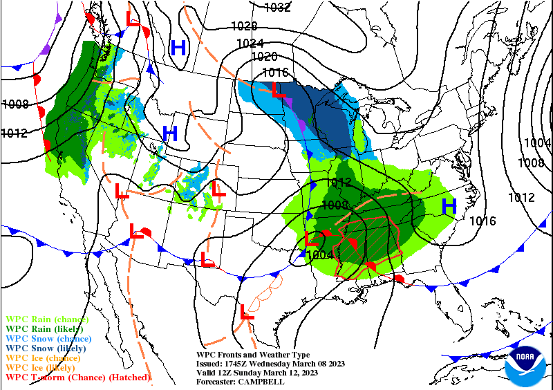
The clouds and showers moving through our region this afternoon are partly because of that stalled front around Mobile slowly lifting northward but more from the weak upper-level disturbance moving out of the Plains.
The rain extends back through the Mid-South and the Great Plains. They have snow and ice (again) in the Midwest, Rocky Mountains, to the Pacific Northwest. Looks like that has tapered off a bit for New England. Looks like fair weather at the moment for the Ohio Valley and Great Lakes region. They have sunshine in the Desert Southwest for the most part, mild temperatures right now similar to what ours have been lately, except more 30's at night due to the lower humidity out that way.
As the next front moves along tomorrow, our rain chances will increase.
We could see some thunderstorms too, although overall here we are not concerned with severe weather potential for this one.
The Storm Prediction Center has outlooked some of Northwest Alabama for a marginal 5% risk of a thunderstorm producing severe hail and/or winds tomorrow/tomorrow night.

We could see an isolated strong storm that reaches severe criteria (50 knot winds or hail an inch in diameter), but this chance is very low.
Especially as cool as it is going to be for a lot of us. For Cullman expecting a High of about 57 and a Low of about 50 or 51. The timing of this front has speeded up a bit, and most of our rain will come tomorrow and tomorrow night instead of on Friday. The rain may be heavy at times, and people in flood-prone areas, you know we've had a lot of rain lately and to keep an eye on it.
Friday we will be clearing out through the day. The rain will linger through part of the morning, but by late morning I think we will be dry. And the sun should break out for midday and the afternoon. Expecting a Low near 50 or so again and then warming up to about 62 or 63 in the afternoon.
High pressure over the Ohio River Valley will keep plenty of sunshine around here on Saturday. Look for a High of 60 or so, Low down into the mid-30's with a shot of dry air.
Which doesn't last long . . .
Another storm system is coming at us on Sunday.
The severe weather potential may be a little better with this one than tomorrow's, but for the moment instability is still looking limited for North Alabama. Taking a forecast sounding down around Smith Lake, it is showing what would mainly be a threat for damaging wind gusts, outside chance of an isolated tornado, but probably not enough unstable air to use that wind energy and sustain either one.
The high-resolution ECMWF continues to show dewpoints getting up to 60 degrees or higher on the Alabama side, with stabler air up in Tennessee for Sunday. So this does bear watching. It can be tough for models to predict two storm systems back to back. But since our only break in the action is Friday afternoon and Saturday, need to pay attention to it now, just in case any storms do try to get rowdy from this second system.
Will forecast a High in the upper 60's and a Low in the upper 40's for Sunday.
Might be a shower or two left early Monday morning, but I doubt we'll even see that. Should become partly to mostly sunny by afternoon with a High in the mid-50's, morning Low should be in the lower 40's, with moisture around keeping from cooling too quickly behind the front.
Then on Tuesday with high pressure centered over the Midwest, we get the serious shot of cold air. If you've got anything planted already, it could hurt them. Really need to wait until April to start the growing season, and maybe give it at least a week, better if you give it two weeks into April to make sure no more late-season cold snaps. We'll start Tuesday near freezing and then only warm up to about 50 or so, plenty of sunshine, but feeling like going back to Winter time.
Then the high pressure moves through Tennessee and Kentucky on Wednesday of next week, a week from today. Our High could get into the upper 50's under sunny skies, but the morning should be below freezing, maybe even dipping into the upper 20's.
We could see about two inches of additional rainfall tomorrow through very early Monday morning. Locally heavier amounts are possible of course, and we can't rule out isolated instances of flash flooding or flooding of bodies of water. But the WPC only has us under a marginal risk for anything like that, even by Sunday.


No comments:
Post a Comment