


That large tan box is a special weather statement out ahead of the squall line. that segment of the line coming from Tupelo bears careful watching to see if the storms remain severe as they cross the Alabama state line.
4:15 AM - That severe thunderstorm should be close to Hamilton within the next 45 minutes. The National Weather Service in Birmingham is watching it closely.

Okay actually they've extended it into Marion County.
Also includes most of Lamar County until 5:15 AM. Wind gusts up to 60 mph and penny sized hail are expected as these storms arrive.

4:38 AM - And now we also have a Severe Thunderstorm Warning for eastern Moore and Franklin Counties in Tennessee. Any part of this squall line has the potential to go severe. And these are the areas where wind gusts up to 60 mph are possible.
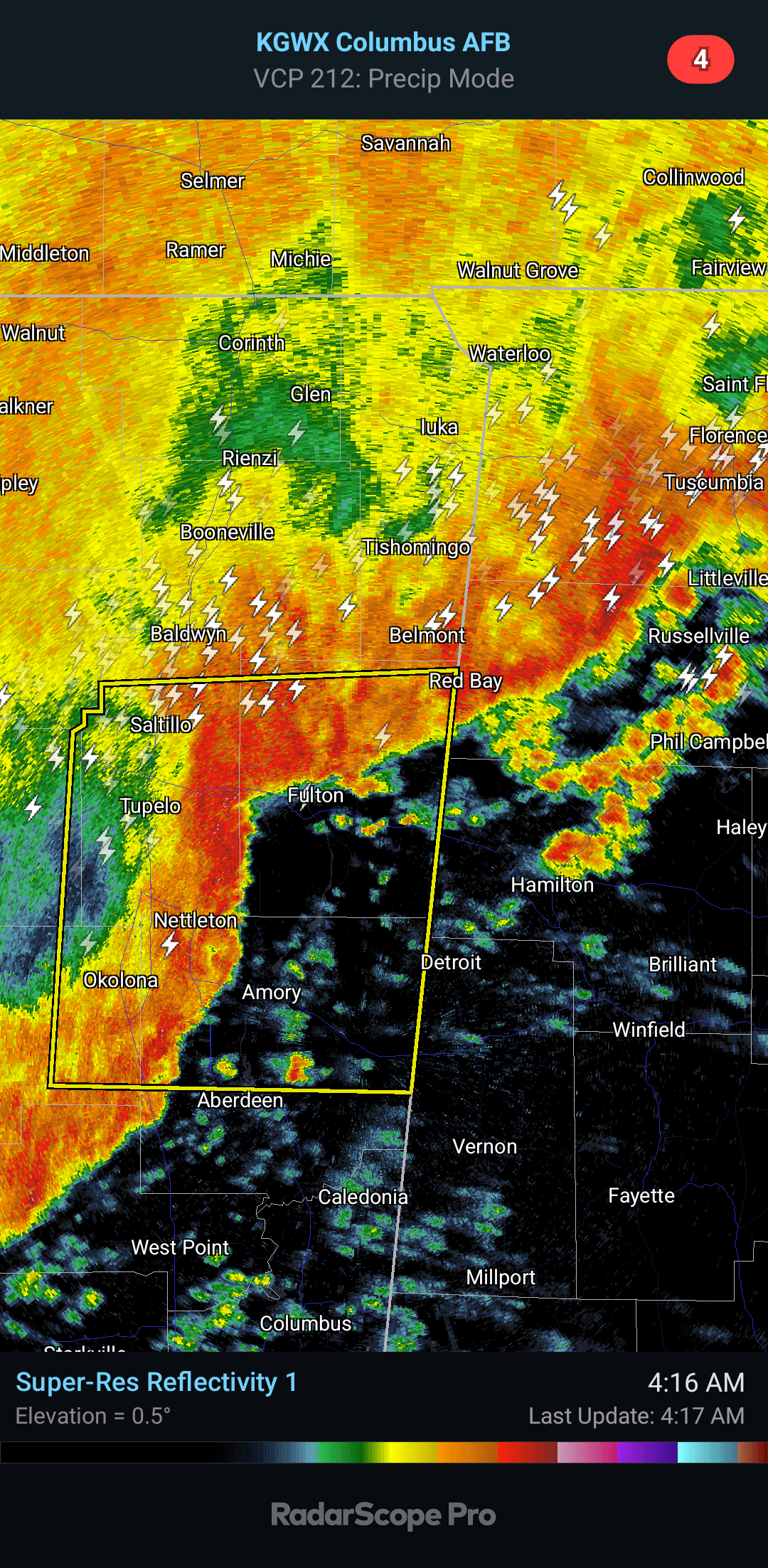
Severe Thunderstorm Warning
MSC017-057-081-095-115-150945-
/O.NEW.KMEG.SV.W.0028.240315T0903Z-240315T0945Z/
BULLETIN - IMMEDIATE BROADCAST REQUESTED
Severe Thunderstorm Warning
National Weather Service Memphis TN
403 AM CDT Fri Mar 15 2024
The National Weather Service in Memphis has issued a
* Severe Thunderstorm Warning for...
Northeastern Chickasaw County in northeastern Mississippi...
Southeastern Pontotoc County in northeastern Mississippi...
Itawamba County in northeastern Mississippi...
Lee County in northeastern Mississippi...
Monroe County in northeastern Mississippi...
* Until 445 AM CDT.
* At 403 AM CDT, severe thunderstorms were located along a line
extending from near Blair to near Verona to near Trebloc, moving
east at 25 mph.
HAZARD...60 mph wind gusts and nickel size hail.
SOURCE...Radar indicated.
IMPACT...Expect damage to roofs, siding, and trees.
* Locations impacted include...
Tupelo, Amory, Aberdeen, Fulton, Verona, Okolona, Tombigbee State
Park, Saltillo, Guntown, Shannon, Plantersville, Mantachie,
Smithville, Tremont, Fairview, New Salem, Sandy Springs, New Wren,
Evergreen, and Clay.
PRECAUTIONARY/PREPAREDNESS ACTIONS...
Remain alert for a possible tornado! Tornadoes can develop quickly
from severe thunderstorms. If you spot a tornado go at once into the
storm shelter or small central room in a sturdy structure.
&&
LAT...LON 3383 8824 3384 8888 3436 8884 3437 8882
3439 8882 3439 8879 3443 8879 3445 8816
TIME...MOT...LOC 0903Z 271DEG 22KT 3442 8878 3421 8876 3387 8885
TORNADO...POSSIBLE
HAIL THREAT...RADAR INDICATED
MAX HAIL SIZE...0.88 IN
WIND THREAT...RADAR INDICATED
MAX WIND GUST...60 MPH
$$
CJC


No comments:
Post a Comment