


SEL5
URGENT - IMMEDIATE BROADCAST REQUESTED
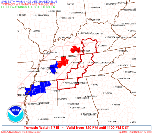
Tornado Watch Number 715
NWS Storm Prediction Center Norman OK
320 PM CST Sat Dec 9 2023
The NWS Storm Prediction Center has issued a
* Tornado Watch for portions of
Northern Alabama
Southern Kentucky
Middle Tennessee
* Effective this Saturday afternoon and evening from 320 PM until
1100 PM CST.
* Primary threats include...
A few tornadoes possible
Scattered damaging wind gusts to 70 mph possible
SUMMARY...Severe thunderstorms including a few long-lived supercells
will move across the region late this afternoon and evening, with
the potential for all severe hazards including a few tornadoes as
well as damaging winds and some hail.
The tornado watch area is approximately along and 40 statute miles
east and west of a line from 30 miles northwest of London KY to 30
miles south southeast of Muscle Shoals AL. For a complete depiction
of the watch see the associated watch outline update (WOUS64 KWNS
WOU5).
WOUS64 KWNS 092118
WOU5
BULLETIN - IMMEDIATE BROADCAST REQUESTED
TORNADO WATCH OUTLINE UPDATE FOR WT 715
NWS STORM PREDICTION CENTER NORMAN OK
320 PM CST SAT DEC 9 2023
TORNADO WATCH 715 IS IN EFFECT UNTIL 1100 PM CST FOR THE
FOLLOWING LOCATIONS
ALC033-059-077-079-083-089-103-100500-
/O.NEW.KWNS.TO.A.0715.231209T2120Z-231210T0500Z/
AL
. ALABAMA COUNTIES INCLUDED ARE
COLBERT FRANKLIN LAUDERDALE
LAWRENCE LIMESTONE MADISON
MORGAN
KYC001-021-045-053-057-137-147-155-199-203-207-217-231-100500-
/O.NEW.KWNS.TO.A.0715.231209T2120Z-231210T0500Z/
KY
. KENTUCKY COUNTIES INCLUDED ARE
ADAIR BOYLE CASEY
CLINTON CUMBERLAND LINCOLN
MARION MCCREARY PULASKI
ROCKCASTLE RUSSELL TAYLOR
WAYNE
TNC003-015-027-031-035-041-049-051-055-061-087-103-117-127-133-
137-141-175-177-185-100500-
/O.NEW.KWNS.TO.A.0715.231209T2120Z-231210T0500Z/
TN
. TENNESSEE COUNTIES INCLUDED ARE
BEDFORD CANNON CLAY
COFFEE CUMBERLAND DE KALB
FENTRESS FRANKLIN GILES
GRUNDY JACKSON LINCOLN
MARSHALL MOORE OVERTON
PICKETT PUTNAM VAN BUREN
WARREN WHITE
ATTN...WFO...HUN...OHX...JKL...LMK...
PRECAUTIONARY/PREPAREDNESS ACTIONS...
REMEMBER...A Tornado Watch means conditions are favorable for
tornadoes and severe thunderstorms in and close to the watch
area. Persons in these areas should be on the lookout for
threatening weather conditions and listen for later statements
and possible warnings.
&&
OTHER WATCH INFORMATION...CONTINUE...WW 714...
AVIATION...Tornadoes and a few severe thunderstorms with hail
surface and aloft to 1 inch. Extreme turbulence and surface wind
gusts to 60 knots. A few cumulonimbi with maximum tops to 450. Mean
storm motion vector 24040.
...Guyer


No comments:
Post a Comment