

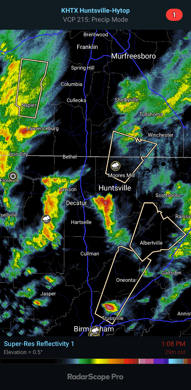
So we've still got that storm moving into Fayetteville and now one coming up on Albertville out of Blount County. Also a strong storm cluster up in Hickman County, TN. These storms are managing to stay just under severe limits, producing some strong wind gusts up to 50 mph or so and some hail under one inch in diameter.
If the air was just a little warmer I'd be concerned about that Albertville storm being all out by itself. But the dewpoint there is 55, not 65.
And there is a power outage in Northwest parts of Huntsville, but Huntsville Utilities is on top of it.
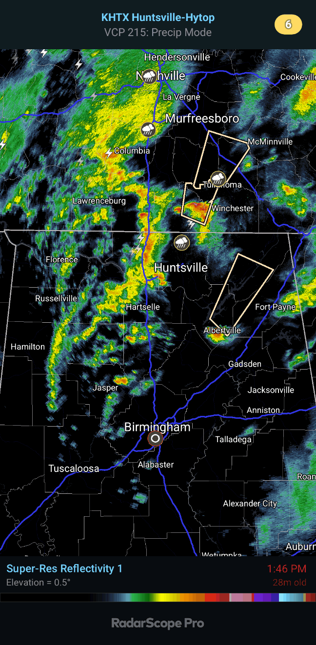
2:15 - Power was restored to that part of Huntsville. We've got a couple strong storms still with winds about 40 mph gusts, small hail possible. One is moving from Lynchburg up toward Shelbyville in Tennessee. Another is heading up toward Scottsboro. The hail could get up to about penny size.

2:21 - And another strong thunderstorm affecting Eva and Morgan City. These are all staying under severe limits.

3:47 PM - Another special weather statement for Madison County, includes Huntsville, as winds could gust up to 50 mph while this line of showers and thunderstorms blows through.

Actually several counties are included . . .

And this stuff is just about out of the region. Going to work on a forecast.
Special Weather Statement
National Weather Service Huntsville AL
133 PM CST Mon Feb 12 2024
ALZ008-010-122000-
Marshall AL-DeKalb AL-
133 PM CST Mon Feb 12 2024
...A STRONG THUNDERSTORM WILL IMPACT MARSHALL AND SOUTHWESTERN DEKALB
COUNTIES THROUGH 200 PM CST...
At 133 PM CST, Doppler radar was tracking a strong thunderstorm over
Susan Moore, or near Oneonta, moving northeast at 65 mph.
HAZARD...Wind gusts of 50 to 55 mph and nickel size hail.
SOURCE...Radar indicated.
IMPACT...Gusty winds could knock down tree limbs and blow around
unsecured objects. Minor hail damage to vegetation is
possible.
Locations impacted include...
Albertville, Boaz, Guntersville, Crossville, Grant, Geraldine,
Douglas, Lakeview, High Point, and Skirum.
PRECAUTIONARY/PREPAREDNESS ACTIONS...
If outdoors, consider seeking shelter inside a building.
&&
LAT...LON 3423 8643 3460 8628 3460 8619 3456 8615
3452 8614 3453 8613 3452 8610 3451 8611
3446 8608 3448 8604 3433 8585 3420 8603
3420 8611 3419 8611 3418 8619 3410 8630
TIME...MOT...LOC 1933Z 205DEG 55KT 3404 8643
MAX HAIL SIZE...0.88 IN
MAX WIND GUST...55 MPH
$$
HC
Special Weather Statement
National Weather Service Huntsville AL
128 PM CST Mon Feb 12 2024
ALZ006-TNZ096-097-121945-
Madison AL-Franklin TN-Lincoln TN-
128 PM CST Mon Feb 12 2024
...A STRONG THUNDERSTORM WILL IMPACT NORTHERN MADISON...SOUTHEASTERN
LINCOLN AND SOUTHWESTERN FRANKLIN COUNTIES THROUGH 145 PM CST...
At 127 PM CST, Doppler radar was tracking a strong thunderstorm over
Hazel Green, or near Meridianville, moving northeast at 65 mph.
HAZARD...Wind gusts in excess of 30 mph and penny size hail.
SOURCE...Radar indicated.
IMPACT...Gusty winds could knock down tree limbs and blow around
unsecured objects. Minor hail damage to vegetation is
possible.
Locations impacted include...
Northern Huntsville, Fayetteville, Moores Mill, Meridianville, Hazel
Green, Huntland, New Market, Lincoln, Plevna, and Elora.
PRECAUTIONARY/PREPAREDNESS ACTIONS...
If outdoors, consider seeking shelter inside a building.
&&
LAT...LON 3515 8637 3512 8636 3515 8635 3512 8633
3513 8631 3514 8632 3510 8615 3499 8626
3499 8631 3498 8631 3496 8629 3477 8648
3485 8668 3521 8660
TIME...MOT...LOC 1927Z 204DEG 60KT 3491 8653
MAX HAIL SIZE...0.75 IN
MAX WIND GUST...30 MPH
$$
HC
Special Weather Statement
National Weather Service Nashville TN
125 PM CST Mon Feb 12 2024
TNZ057-058-094-122000-
Hickman TN-Lawrence TN-Lewis TN-
125 PM CST Mon Feb 12 2024
...A STRONG THUNDERSTORM WILL IMPACT LEWIS...NORTHWESTERN LAWRENCE
AND SOUTHEASTERN HICKMAN COUNTIES THROUGH 200 PM CST...
At 125 PM CST, Doppler radar was tracking a strong thunderstorm 9
miles south of Hohenwald, moving north at 50 mph.
HAZARD...Wind gusts up to 40 mph and pea size hail.
SOURCE...Radar indicated.
IMPACT...Gusty winds could knock down tree limbs and blow around
unsecured objects. Minor hail damage to vegetation is
possible.
Locations impacted include...
Hohenwald, Centerville, Gordonsburg, Kimmins, and Henryville.
PRECAUTIONARY/PREPAREDNESS ACTIONS...
If outdoors, consider seeking shelter inside a building.
Torrential rainfall is also occurring with this storm and may lead to
localized flooding. Do not drive your vehicle through flooded
roadways.
&&
LAT...LON 3534 8758 3541 8757 3543 8761 3582 8755
3579 8728 3568 8731 3562 8735 3559 8735
3558 8734 3532 8741
TIME...MOT...LOC 1925Z 189DEG 47KT 3542 8750
MAX HAIL SIZE...0.25 IN
MAX WIND GUST...40 MPH
$$
Clements
Special Weather Statement
National Weather Service Birmingham AL
110 PM CST Mon Feb 12 2024
ALZ017-018-024-026-121945-
Etowah AL-Jefferson AL-St. Clair AL-Blount AL-
110 PM CST Mon Feb 12 2024
...A STRONG THUNDERSTORM WILL IMPACT BLOUNT...WEST CENTRAL ETOWAH...
NORTHEASTERN JEFFERSON AND WEST CENTRAL ST. CLAIR COUNTIES THROUGH
145 PM CST...
At 110 PM CST, Doppler radar was tracking a strong thunderstorm over
Chalkville, or near Trussville, moving northeast at 55 mph.
HAZARD...Nickel size hail.
SOURCE...Radar indicated.
IMPACT...Minor hail damage to vegetation is possible.
Locations impacted include...
Northeastern Birmingham, Trussville, Gardendale, Oneonta,
Springville, Blountsville, Cleveland, Dallas, Center Point, Clay,
Pinson, Argo, Locust Fork, Altoona, Snead, Susan Moore, Walnut Grove,
Allgood, Fairview, and Nectar.
PRECAUTIONARY/PREPAREDNESS ACTIONS...
If outdoors, consider seeking shelter inside a building.
&&
LAT...LON 3418 8638 3410 8630 3413 8626 3411 8621
3356 8661 3365 8679 3417 8657 3419 8655
3422 8655 3423 8652
TIME...MOT...LOC 1910Z 212DEG 49KT 3369 8664
MAX HAIL SIZE...0.88 IN
MAX WIND GUST...<30 MPH
$$
56
Special Weather Statement
National Weather Service Memphis TN
410 AM CST Mon Feb 12 2024
ARZ009-018-026>028-MOZ113-115-TNZ001>004-019>022-048>052-054-055-
122315-
Clay-Greene-Craighead-Poinsett-Mississippi-Dunklin-Pemiscot-Lake-
Obion-Weakley-Henry-Dyer-Gibson-Carroll-Benton TN-Lauderdale-
Tipton-Haywood-Crockett-Madison-Henderson-Decatur-
Including the cities of Piggott, Corning, Paragould, Jonesboro,
Harrisburg, Blytheville, Kennett, Caruthersville, Tiptonville,
Union City, Martin, Dresden, Paris, Dyersburg, Humboldt, Milan,
Huntingdon, Camden, Ripley TN, Covington, Brownsville, Alamo,
Jackson, Lexington, Parsons, and Decaturville
410 AM CST Mon Feb 12 2024
...LIGHT SNOW ACCUMULATIONS POSSIBLE THIS AFTERNOON AND EVENING...
A low pressure system will bring precipitation chances to the
Mid-South today. Beginning late in the afternoon, a rain-snow
changeover may develop in northeast Arkansas, the Missouri
Bootheel, and west Tennessee. At the surface, temperatures will
remain above freezing. However, moderate snowfall rates may result
in light accumulations on elevated surfaces. Any accumulation
will likely melt before Tuesday morning, but some travel impacts
may occur this evening.
$$


No comments:
Post a Comment