

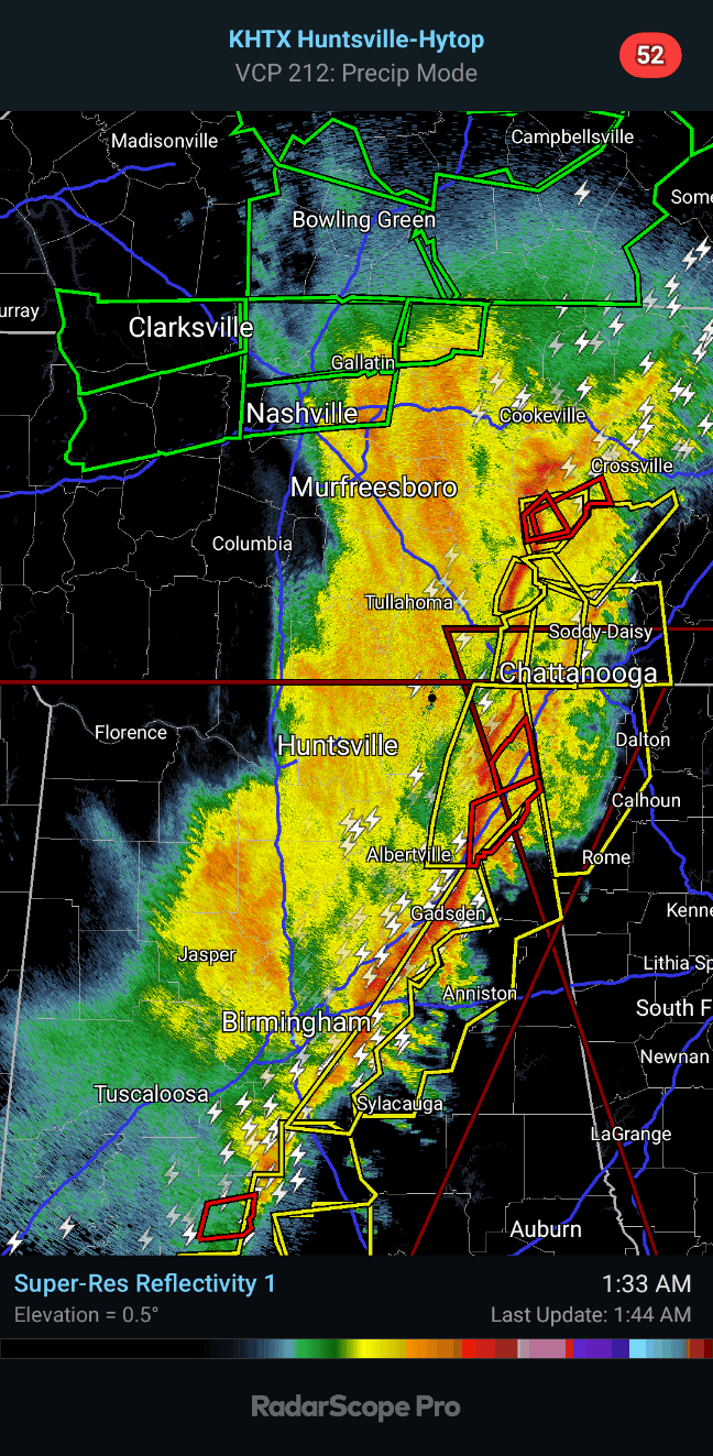

This squall line is nearly over into Georgia now, but let's remember our folks in Northeast Alabama who mainly live in rural communities. Everybody along and ahead of this line needs to stay sheltered.


Severe Weather Statement
National Weather Service Huntsville AL
135 AM CST Sun Feb 16 2025
ALC049-160815-
/O.CON.KHUN.TO.W.0011.000000T0000Z-250216T0815Z/
DeKalb AL-
135 AM CST Sun Feb 16 2025
...A TORNADO WARNING REMAINS IN EFFECT UNTIL 215 AM CST FOR
SOUTHEASTERN DEKALB COUNTY...
At 135 AM CST, a severe thunderstorm capable of producing a tornado
was located near Fort Payne, moving northeast at 75 mph.
HAZARD...Tornado and quarter size hail.
SOURCE...Radar indicated rotation.
IMPACT...Flying debris will be dangerous to those caught without
shelter. Mobile homes will be damaged or destroyed. Damage
to roofs, windows, and vehicles will occur. Tree damage is
likely.
Locations impacted include...
Fort Payne, Rainsville, Valley Head, Hammondville, Mentone, Pine
Ridge, Dog Town, Collbran, Guest, and Little River Canyon NP.
PRECAUTIONARY/PREPAREDNESS ACTIONS...
Tornadoes are extremely difficult to see and confirm at night. Do not
wait to see or hear the tornado. TAKE COVER NOW!
&&
LAT...LON 3448 8558 3444 8558 3437 8563 3436 8566
3426 8577 3426 8581 3424 8581 3424 8584
3420 8585 3420 8589 3447 8587 3459 8553
3453 8551
TIME...MOT...LOC 0735Z 241DEG 66KT 3440 8578
TORNADO...RADAR INDICATED
MAX HAIL SIZE...1.00 IN
$$
70/DD
Severe Weather Statement
National Weather Service Huntsville AL
132 AM CST Sun Feb 16 2025
ALC049-071-160800-
/O.CON.KHUN.TO.W.0009.000000T0000Z-250216T0800Z/
Jackson AL-DeKalb AL-
132 AM CST Sun Feb 16 2025
...A TORNADO WARNING REMAINS IN EFFECT UNTIL 200 AM CST FOR
SOUTHEASTERN JACKSON AND NORTHEASTERN DEKALB COUNTIES...
At 131 AM CST, a severe thunderstorm capable of producing a tornado
was located over Sylvania, or near Rainsville, moving east at 55 mph.
HAZARD...Tornado and quarter size hail.
SOURCE...Radar indicated rotation.
IMPACT...Flying debris will be dangerous to those caught without
shelter. Mobile homes will be damaged or destroyed. Damage
to roofs, windows, and vehicles will occur. Tree damage is
likely.
This dangerous storm will be near...
Henagar and Sylvania around 135 AM CST.
Other locations impacted by this tornadic thunderstorm include
Sulpher Springs, Hammondville, Rosalie, Valley Head, and Mentone.
PRECAUTIONARY/PREPAREDNESS ACTIONS...
Tornadoes are extremely difficult to see and confirm at night. Do not
wait to see or hear the tornado. TAKE COVER NOW!
&&
LAT...LON 3447 8587 3461 8590 3484 8559 3478 8557
3459 8553
TIME...MOT...LOC 0731Z 253DEG 50KT 3457 8582
TORNADO...RADAR INDICATED
MAX HAIL SIZE...1.00 IN
$$
70/DD
Severe Weather Statement
National Weather Service Nashville TN
136 AM CST Sun Feb 16 2025
TNC175-160745-
/O.CON.KOHX.TO.W.0004.000000T0000Z-250216T0745Z/
Van Buren TN-
136 AM CST Sun Feb 16 2025
...A TORNADO WARNING REMAINS IN EFFECT UNTIL 145 AM CST FOR
NORTHWESTERN VAN BUREN COUNTY...
At 136 AM CST, a severe thunderstorm capable of producing a tornado
was located near Spencer, moving northeast at 45 mph.
HAZARD...Tornado.
SOURCE...Radar indicated rotation.
IMPACT...Flying debris will be dangerous to those caught without
shelter. Mobile homes will be damaged or destroyed. Damage
to roofs, windows, and vehicles will occur. Tree damage is
likely.
This dangerous storm will be near...
Spencer around 140 AM CST.
Other locations impacted by this tornadic thunderstorm include Fall
Creek Falls State Park.
PRECAUTIONARY/PREPAREDNESS ACTIONS...
TAKE COVER NOW! Move to a basement or an interior room on the lowest
floor of a sturdy building. Avoid windows. If you are outdoors, in a
mobile home, or in a vehicle, move to the closest substantial shelter
and protect yourself from flying debris.
&&
LAT...LON 3565 8536 3561 8558 3572 8560 3581 8548
TIME...MOT...LOC 0736Z 245DEG 41KT 3576 8552
TORNADO...RADAR INDICATED
MAX HAIL SIZE...<.75 IN
$$
Barnwell


No comments:
Post a Comment