


Please take cover in the Tornado Warning polygons but also in the Severe Thunderstorm Warning polygons. Trees and power lines have been reported down with this line back in Mississippi. And it's tough to confirm damage - tornado or otherwise - at night.

@spann MS-155 Guntown, Mississippi pic.twitter.com/5Z9kVyGptS
— Brandon little (@thevestavia) February 16, 2025
182
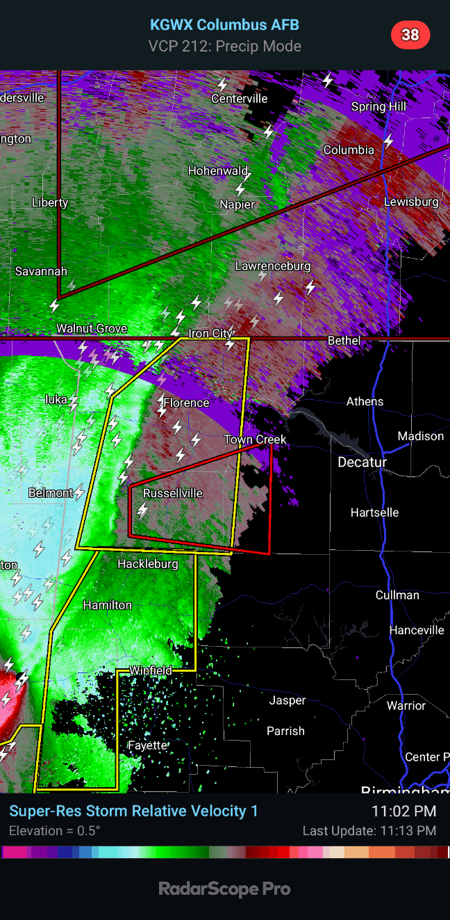
WFUS54 KHUN 160456
TORHUN
ALC033-059-079-160530-
/O.NEW.KHUN.TO.W.0001.250216T0456Z-250216T0530Z/
BULLETIN - EAS ACTIVATION REQUESTED
Tornado Warning
National Weather Service Huntsville AL
1056 PM CST Sat Feb 15 2025
The National Weather Service in Huntsville Alabama has issued a
* Tornado Warning for...
Southeastern Colbert County in northwestern Alabama...
Franklin County in northwestern Alabama...
Southwestern Lawrence County in northwestern Alabama...
* Until 1130 PM CST.
* At 1055 PM CST, a line of severe thunderstorms capable of
producing a tornado was located near Red Bay, moving east at 55
mph.
HAZARD...Tornado and quarter size hail.
SOURCE...Radar indicated rotation.
IMPACT...Flying debris will be dangerous to those caught without
shelter. Mobile homes will be damaged or destroyed.
Damage to roofs, windows, and vehicles will occur. Tree
damage is likely.
* This dangerous storm will be near...
Belgreen around 1105 PM CST.
Russellville around 1110 PM CST.
Other locations impacted by this tornadic thunderstorm include Mt
Hope, Cedar Creek Reservoir, Atwood, La Grange, Tharptown, Ne Smith,
Duketon, Rockwood, Vina, and Landersville.
PRECAUTIONARY/PREPAREDNESS ACTIONS...
TAKE COVER NOW! Move to a basement or an interior room on the lowest
floor of a sturdy building. Avoid windows. If you are outdoors, in a
mobile home, or in a vehicle, move to the closest substantial shelter
and protect yourself from flying debris.
Tornadoes are extremely difficult to see and confirm at night. Do not
wait to see or hear the tornado. TAKE COVER NOW!
&&
LAT...LON 3451 8815 3467 8734 3430 8735 3432 8817
TIME...MOT...LOC 0455Z 256DEG 49KT 3440 8806
TORNADO...RADAR INDICATED
MAX HAIL SIZE...1.00 IN
$$
KDW


No comments:
Post a Comment