

Damaging tornado heading into Madison right now!!!!! @NWSHuntsville pic.twitter.com/sm5Zh39Emd
— Brad Arnold (@BradArnoldWX) May 20, 2025
In a situation like this, radar becomes secondary. Above you can see a picture of this tornado.
Please take this very, very seriously. Take the best precautions you can. Cover your head in your shelter - with a helmet if you can.
Lowest floor - basement if you've got one - small room or hallway away from windows - put as many walls between you and the storm outside as you can.
And stay there until sure this thing is past.
THIS IS NOTHING TO FOOL AROUND WITH.
Live streams - Jeff Castle, Brad Travis, James Spann are the ones I've been following. WHNT is on top of it too I'm sure, their site just isn't as easy to access these days. But stay tuned to a reliable source FROM A SAFE PLACE.


6:37 - It looks like this tornado is moving through the Northern parts of Madison and Huntsville.
They have issued the highest threat level, calling this tornado large and destructive. Places like UAH, Alabama A & M, Redstone Arsenal, are in danger from this.
This is a very serious situation. I don't know of a live video stream of the tornado, but this has the potential to be really destructive. We wouldn't want an outcome like what happened in 1989. People have had time to get to shelter for this one. Hope everyone is taking this seriously. Seems like they are.
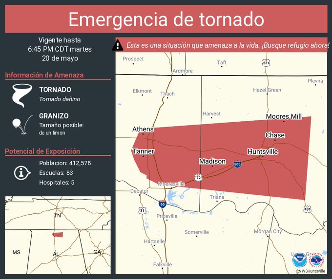
6:41 - For the Hispanics among us - bajo de casa, centro de casa . . . lejos de ventanas . . .
Along Newby Rd. 5 minutes ago, just east of Athens. #alwx @spann @simpsonWVTM13 @abc3340 pic.twitter.com/2G5KTzCw1u
— Andrew Gwin (@andrewgwin) May 20, 2025
6:43 - Above you can see video and pictures of this tornado from earlier. I am not aware of a live camera on it yet. There may be one soon. Sometimes they are rain-wrapped even if they are doing a lot of damage though.

6:46 - Radar update while I scan for anybody catching this live on video. Take it seriously even without live video though. This could kill people.
Passing by UAH, no damage reported there yet . . . maybe it stays that way. But this situation is very dangerous. You can't fool around with a situation like this. You have to take shelter.
Along Newby Rd. 5 minutes ago, just east of Athens. #alwx @spann @simpsonWVTM13 @abc3340 pic.twitter.com/2G5KTzCw1u
— Andrew Gwin (@andrewgwin) May 20, 2025
6:51 - And the Tornado Emergency is over, replaced by a new Tornado Warning.
Going to start a new post.
Severe Weather Statement
National Weather Service Huntsville AL
624 PM CDT Tue May 20 2025
ALC083-089-202345-
/O.CON.KHUN.TO.W.0042.000000T0000Z-250520T2345Z/
Madison AL-Limestone AL-
624 PM CDT Tue May 20 2025
...TORNADO EMERGENCY FOR WESTERN MADISON COUNTY AND EASTERN
LIMESTONE COUNTY...
...A TORNADO WARNING REMAINS IN EFFECT UNTIL 645 PM CDT FOR
SOUTHWESTERN MADISON AND SOUTHEASTERN LIMESTONE COUNTIES...
At 622 PM CDT, a confirmed large and destructive tornado was located
near Madison, moving east at 35 mph.
TORNADO EMERGENCY FOR WESTERN MADISON AND EASTERN LIMESTONE COUNTY.
This is a PARTICULARLY DANGEROUS SITUATION. TAKE COVER NOW!
HAZARD...Deadly tornado.
SOURCE...Radar confirmed tornado.
IMPACT...You are in a life-threatening situation. Flying debris may
be deadly to those caught without shelter. Mobile homes
will be destroyed. Considerable damage to homes,
businesses, and vehicles is likely and complete destruction
is possible.
The tornado will be near...
Madison and Huntsville around 630 PM CDT.
University Of Alabama In Huntsville and Redstone Arsenal around
635 PM CDT.
Alabama A And M University around 645 PM CDT.
Other locations impacted by this tornadic thunderstorm include Belle
Mina, French Mill, Mooresville, Capshaw, Ryland, Hampton Cove,
Ripley, Brownsboro, and Farley.
PRECAUTIONARY/PREPAREDNESS ACTIONS...
To repeat, a large, extremely dangerous, and potentially deadly
tornado is on the ground. To protect your life, TAKE COVER NOW! Move
to an interior room on the lowest floor of a sturdy building. Avoid
windows. If in a mobile home, a vehicle or outdoors, move to the
closest substantial shelter and protect yourself from flying debris.
&&
LAT...LON 3486 8643 3459 8645 3462 8698 3465 8703
3465 8705 3467 8709 3470 8713 3472 8713
3473 8715 3481 8715
TIME...MOT...LOC 2322Z 265DEG 31KT 3473 8684
TORNADO...OBSERVED
TORNADO DAMAGE THREAT...CATASTROPHIC
MAX HAIL SIZE...2.00 IN
$$
KTW


No comments:
Post a Comment